There are thriving settlements, dying ones, and there are dead ones. The latter always attract a large number of tourists and extreme sports enthusiasts. The main topic of this article is the abandoned villages of the Moscow region. It’s very difficult to say how many there are in the Moscow region, and indeed in Russia in general. After all, new abandoned villages appear every year. You can also see photos of these villages in this article.
- Russia's problem
It is not for nothing that they say that this is the soul of the country and the people. And if a village dies, then the whole country dies. It is very difficult to disagree with this statement. After all, the village is truly the cradle of Russian culture and traditions, the Russian spirit and Russian poetry.
Unfortunately, abandoned ones are not uncommon today. Modern Russians increasingly prefer an urban lifestyle, breaking away from their roots. Meanwhile, the village is degrading and more and more abandoned villages are appearing on the map of Russia, photos of which are striking in their despondency and melancholy.
But, on the other hand, such objects attract a large number of tourists and so-called stalkers - people eager to visit various kinds of abandoned places. Thus, abandoned villages in Russia can become a good resource for the development of extreme tourism.
However, the state should not forget about the problems of the Russian village, which can only be solved through a complex of various measures - economic, social and propaganda.
Abandoned villages in Russia - reasons for the degradation of villages
The word "village" comes from "to tear" - that is, to cultivate the land. It is very difficult to imagine authentic Russia without villages - a symbol of the Russian spirit. However, the realities of our time are such that the village is dying, a huge number of once flourishing villages simply cease to exist. What's the matter? What are the reasons for these sad processes?
Perhaps the main reason is urbanization - the process of rapidly increasing the role of the city in the life of society. Large cities are attracting more and more people, especially young people. Young people leave for the cities to get an education and, as a rule, never return to their native village. Over time, only old people remain in the villages and live out their lives there, as a result of which the villages die out. For this reason, almost all the abandoned villages of the Moscow region appeared.

Another fairly common reason for the degradation of villages is the lack of jobs. Many villages in Russia suffer from this problem, as a result of which their residents are also forced to go to cities in search of work. Villages can disappear for other reasons. For example, it could be a man-made disaster. Villages can also degrade due to changes in their economic and geographical location. For example, if the direction of the road changes, thanks to which a particular village has been developing all this time.
Moscow region - the land of ancient churches and estates

Moscow region is an unofficial name. The historical predecessor of this region can be considered the Moscow province, which was formed back in 1708.
The Moscow region is one of the leading regions in terms of the number of cultural heritage sites in Russia. This is a real paradise for tourists and travelers: more than a thousand ancient temples and monasteries, dozens of beautiful estates, as well as numerous places with long-standing traditions of folk arts and crafts. It is in the Moscow region that such ancient and interesting cities as Zvenigorod, Istra, Sergiev Posad, Dmitrov, Zaraysk and others are located.
At the same time, the abandoned villages of the Moscow region are also on the lips of many. There are quite a lot of them in this region. The most interesting abandoned villages of the Moscow region will be discussed further.
Such objects attract primarily extreme sports enthusiasts, as well as local historians and various antiquity lovers. There are quite a lot of such places. First of all, it is worth mentioning the Fedorovka farm, the villages of Botovo, Grebnevo and Shatur. These abandoned villages of the Moscow region on the map:

Khutor Fedorovka
This farm is located 100 kilometers from Moscow. In fact, this is a former military town, so you won’t find it on any of the maps. Around the beginning of the 90s, the village of 30 residential buildings fell completely into disrepair. At one time there was its own boiler house, substation, and also a store.
Botovo village
The old village of Botovo is located in the Moscow region, near the Volokolamsk station (Riga direction). Once upon a time in this area there was the estate of Princess A.M. Dolgorukova. The center of this estate was a wooden church, which was built in the 16th century (the church has not survived). The last owner of the estate in Botovo, as is known, gave it to the peasants at the beginning of the twentieth century.
Of the surviving objects in Botovo, you can only see the ruins of the Resurrection Church, built in the 1770s in the pseudo-Russian style, as well as the remains of an old park with an area of twenty hectares. There are still old birch and linden alleys in this park.
Village Grebnevo
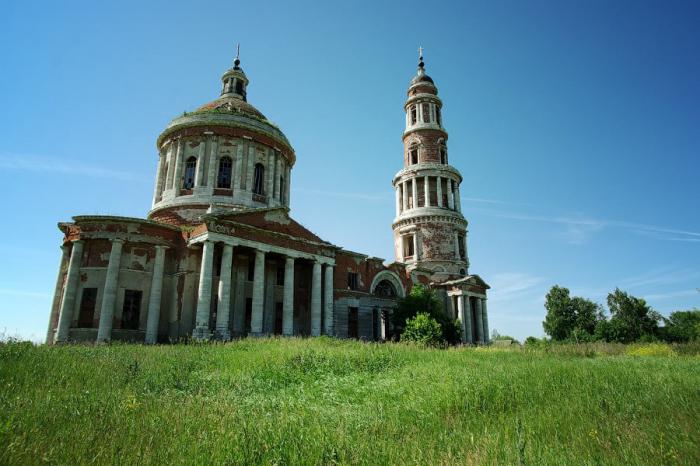
Grebnevo is a 16th-century estate with a rich, interesting history and a rather tragic fate. It is located forty kilometers from the capital, on Shchelkovskoye Highway.
The first owner of the estate was B. Ya. Belsky, the armorer of Tsar Ivan the Terrible, then the estate was owned by the Vorontsovs and Trubetskoys. In 1781, Gavril Ilyich Bibikov became the owner, and it was under him that the estate acquired the appearance in which it has survived to this day.
Dramatic pages in the history of the estate in Grebnevo are associated with the beginning of the Soviet era. The nationalization of the complex led to the fact that the buildings gradually began to lose their historical appearance. First of all, all the interiors of the buildings were damaged. At first, a tuberculosis sanatorium was located within the walls of the estate complex, then a technical school. And only in 1960 the Grebnevo estate was declared an architectural monument of republican significance.
At the end of the 1980s, the estate seemingly received a new impetus for its development and preservation. A cultural center was formed here, and various concerts, events and exhibitions began to be regularly held on the territory of the estate. Active restoration work has begun to restore the complex. But in 1991 there was a huge fire, after which only the frames of the estate buildings and structures remained. The Grebnevo estate remains in this state today, increasingly turning into ordinary ruins.
Village Shatur
The old village of Shatur has been known since the 17th century. It is located on poor soils, so the main occupation of local residents has always been hunting. Perhaps it was for this reason that the village fell into decay in the mid-twentieth century.
Today the village is completely deserted. Occasionally, the owners of individual houses come here (several times a year). Among the abandoned village, the old brick bell tower, towering above the deserted village, looks great.
Memo for extreme tourists
Despite their gloom and decrepitude, old uninhabited villages and other abandoned places are of great interest to many tourists. However, traveling to such sites can be fraught with certain dangers.

What should so-called extreme tourists know?
- firstly, before going on such a trip, you should notify your relatives or friends about your trip, its timing and route;
- secondly, you need to dress appropriately; remember that you are not going for an evening walk in the park: clothes should be closed, and shoes should be reliable, durable and comfortable;
- thirdly, take with you the necessary supply of water and food; your backpack should also have a flashlight, matches and a standard first aid kit.
Finally...

The old villages of the Moscow region amaze travelers with their desolation and picturesqueness. I can’t even believe that such objects can be located just a few tens of kilometers from the capital - the largest metropolis on the planet! Entering one of these villages is like using a time machine. It seems as if time has stood still here...
Unfortunately, the number of abandoned buildings is growing every year. Perhaps someday this problem can be solved. But for now, abandoned villages serve only as objects of interest for all sorts of extreme sports enthusiasts, stalkers and lovers of dark antiquities.
The history of lost settlements that have not survived to this day is an important part of the history of the region.
Today we will talk about the village Lipovets, which existed in the 16th-1st centuries. XVIII centuries on the territory of the Housing Cooperative (Zhilkopa) of the urban settlement of Fryanovo, Shchelkovsky district, Moscow region, village Gridino, at different times called Bravino, Brovkino or Gridkovo, from the beginning of the 16th to the beginning of the 20th century, located on the right bank of the Dubenka River opposite the village of Golovino, a village Kopylovo in the XVI-I half. XVIII century located between Mavrino and Stepankovo, village Lunevo, in the XVIII - first half. XIX century located on the right bank of the river. Melezhi near the village of Bobry and a village with an unusual name Bolokhrystovo, at the beginning of the 16th - first half of the 19th centuries. existed not far from the present Staropareev...

Lipovets
North of Fryanovo along the Sherenka River through the Likhachikha wasteland (as the Endova cliff was called in those days) on the territory of the current Fryanovo Housing Cooperative in XVI century there was the ancient village of Lipovets. It was listed as the estate of Ivan Mikitin's son Boskakov.
Ivan Mikitin son of Boskakov (Baskakov). The Boskakovs were relatives of the Zubovs, who had owned the village since ancient times Gridina, located between and . Both families descended from the Tatar Baskak Amragat (Miragan), who was baptized with the name Zechariah (Martyn).
One of the sons of Amragat, Parthenius, who accepted monasticism with the name Paphnutius, died in 1478 and in 1540 was canonized (Reverend Paphnutius of Borovsky, 1394-1477). His other son, Ivan Boskakov, died in the Kazan campaign of 1547. One of Baskakov’s descendants, Sharap Baskakov, sold a number of his estates to the Trinity Makhrishchi Monastery, but this deal was challenged by Timofey Klobukov, the son of Toporkov, another major estate owner of the Shchelkovo region. The Baskakovs were among the ancient families of the Central Russian districts who had long-standing contacts with representatives of the administration of the Trinity-Sergius Monastery.
Rev. Paphnutius Borovsky.
In the lists of service people, Desyatny 1577, the owner of the village of Lipovets, Ivan Mikitin, son of the Baskakovs, wasmarked as follows: “At the layout shop, the payers said: they don’t know him, he doesn’t live from the layout.”. In other words, a serving man was not allocated land for his service, but lived off his own estates. The commentator of this mention believes that it was Ivan Mikitin Baskakov who owned the village of Lipovets.
The need for money was one of the reasons that forced the owners to part with their ancestral estates. In 1577/78, Ivan Baskakov sold his large village of Aleksino in the Kinelsky camp to the Trinity-Sergius Monastery. Despite the fact that Ivan Boskakov had a son, Evdokim Ivanovich, he, according to his soul, gave the village of Lipovets with the courtyard of patrimonial lands to the Suzdal bishop's house. Later, in 1627, Evdokim tried unsuccessfully to sue a number of his father's ancestral estates at the Trinity-Sergius Monastery. Another son of Ivan Mikitin Boskakov, Ivan, served under the command of Ivan Vasilyevich Sitsky (?-1608), the then owner of the neighboring village. In 1586, I.V. Sitsky repaid Ivan Ivanovich Baskakov with 350 acres of land in the Moscow district. It is interesting that the third son of Ivan Boskakov, Grabysh Ivanov, son of Boskakov, was the nephew of clerk Shemet Ivanov and together with him came into possession of the future Fryanovo. The wife of Ivan Mikitin, son of Boskakov, was the sister of Shemet Ivanov.

So, in 1584-1586, the village of Lipovets, together with the adjacent Likhachikha (Endova) wasteland and the Klimushi wasteland (Klimushino, not far from), passed into the possession of the Suzdal bishop's house: “The village of Lipovets, which was formerly behind Ivan, behind Boskakov, and in it there is a courtyard of the ruler, and Grigory Kirilov, son of the Samsons, lives in it.”. Soon the following were annexed to the possessions of the Suzdal Bishop's House: the Klimushi wasteland (the territory of the Fryanovskaya Factory CJSC), the village of Poreevo (Staropareevo) and the now non-existent villages of Bolohristovo and Ikonnikova (Ikonnikovskaya). The village of Lipovets, being on church property, became deserted in the first half - mid-18th century. On the maps of the General Survey of 1766-1770, the area belonging to the College of Economy was listed as the Lipovitsa wasteland.
Gridina (Bravino, Brovkino, Gridkovo)
On the right bank of the Dubenka River, opposite from the beginning XVI century to the first half XX century there was a village that no longer exists Gridina. IN XVI century, it was the family patrimony of Ivan Zubov, who came from an old noble family, traced back to the Tatar Baskak Amragat (Miragan), who was baptized with the name Zechariah (Martyn) and became the ancestor of the Zubovs and Boskakovs. The relationship of Ivan Zubov with the Boskakovs is all the more interesting because on the territory of the future Fryanovo, in the possession of Ivan Boskakov, there was a village Lipovitsy. In addition, Boskakov’s son was the nephew of clerk Shemet Ivanov and together with him came into possession of the future Fryanovo. Information about the life and work of Ivan Zubov has been lost, but it is known that until 1584-86 the village, which by that time had become a wasteland, came into the possession of his son: “Behind Grigory Ivanov, Zubov’s son, his father’s old patrimony: the wasteland that was the village of Gridin” .
In 1768, the village of Gridina, called “Bravina”, together with its lands, extended to the village of Golovino, located on the other side of the Sherenka River (on the map of 1786-1791 - the river “Reshenka”), and was part of the possession of the village of Golovino of the State Councilor Sergei Ivanovich Protopopov.

D. Brovino on the map 1786-1791
By 1812, the name of the village changed again. This time the village is called “Brovkino”. Then the widow of Sergei Ivanovich, Anna Alekseevna Protopopova, already owned it and the village. Around 1816, the owner sold the village to the son of a famous architect, collegiate assessor A.I. Starov, and sells the village “Gridkovo” (Brovkino) to captain Anatoly Sergeevich Vyazemsky, who owned the village at that time. In 1852, there were 54 serf peasants living in seven households in the village of Gridkovo. After the abolition of serfdom and the purchase of land plots from the owner (1862), there were 8 households and 58 people. At the end of the century, due to the outflow of the population from the village to work, the number of people living in the village decreased. Back in 1882, in the village of “Gridkova” the same number of people lived in 7 houses as 20 years ago, but in 1890 (the same in 1899) only 20 peasants lived in the village. In the same year, 1890, there was a master’s yard-estate near the village, which belonged to the hereditary honorary citizen Alexandra Nikolaevna Smirnova.
After the revolution, in 1926, the village of Gridkovo (Gridina) belonged to the Dubrovinsky village council. There were 12 households and 37 people living here. It is not known exactly when the village ceased to exist in these places. Now there is nothing here that reminds us of her, and the tireless waves of time have erased the memory that our ancestors once lived and died here, dreamed, worked and loved.
Kopylova (Kopyly)
It is worth mentioning another ancient village that has not survived to this day, which existed back in the days when the current village was a wasteland. Between Mavrino and, a little north of the also not preserved village V XVI century there was the now defunct village of Kopylova. The village received its name from the surname of its ancient owner, a patrimonial owner, who could have been the Moscow princely posadnik in Pskov, mentioned in 1510, Yuri Kopyl (Kopylov). Geographically, the village belonged to the Vore-Korzenev camp. The village was an ancient patrimonial possession of the Napolskys - large patrimonial owners of the Kinel district. Until 1573, the unserviceable son of the boyar Fyodor Teplov of Napolsky took the land of the Mavrinskaya wasteland as a quitrent. “Children of the boyars” in those days were called representatives of the landowning class from the crushing clans of the boyars or boyar warriors. Until 1584/1586, the village of Kopylova was deserted, and, apparently, after the death of F.T. Napolsky, passed into the possession of his sons: “For the undergrowth, for the Peasant, and for Ondryushka, for the Fedorov children of Napolsky, their father’s old patrimony of the village. Kopylova, who was formerly behind Fyodor Napolsky, and in her was a courtyard of patrimonial landowners.” . In 1596, Andrei Fedorov, the son of Napolskaya, laid out local land (150 quarters) in Pereslavl Zalessky. Andrei Fedorovich was listed as a non-service and unplaced “novik”, that is, a young man of 15-18 years old, now, in 1596, being accepted for military service. The newcomers who received land salaries this year made up the cadre of figures of the Time of Troubles. Along with him, the son of the owner of the Mavrino wasteland in 1630, Sidor Elizariev, was also included in the “ten novikov”.

A century and a half later, in 1768, the Kopylova wasteland belonged to the owner of the village of Gavrilkovo, Anna Vasilyevna Eropkina, and after her it came into the possession of the court councilor Olga Mikhailovna Potresova. In 1852 the heath was no longer mentioned.
Lunevo
In the old days, Lunevo was located a little to the west of the village on the same right bank of the river. The shallows are a little further upstream. Unfortunately, no documents have survived that could indicate the ancient origins of this lost village. Only its name can tell us this. Many Lunev nobles who owned estates are known to Russian history from the second half XV century. A certain Philip Koptev, son of Lunev, was placed in the Moscow region by 250 chets of the land in the Ten Noviki of 1596.

Seltso Lunevo on the map 1786-1791
In 1768, which became the village of Lunevo, was in the possession of Countess Ekaterina Ivanovna Karamysheva (1716-?, nee Tolstoy) - the wife of the court councilor Nikolai Fedorovich Karamyshev. Ekaterina Ivanovna was the daughter of Count Ivan Petrovich Tolstoy (1685-1786) and Sofia Sergeevna Stroganova (1824-1852). At that time, 40 souls of serfs lived in the village.

In 1812, the village of Lunevo was owned by the wife of the college secretary, the sister of the owner of the neighboring village of Bobry, Anna Karlovna Yanish. Sisters Anna and Elizaveta were the daughters of a professor of medicine, one of the first rectors of the Yaroslavl Demidov School of Higher Sciences, a popularizer of the chemical theory of light, Karl Ivanovich Janisch (1776-1853). During Napoleon's invasion, Anna Karlovna provided 16 warriors from the serf peasants of the village of Lunevo to the militia. In the second quarter XIX century, Lunevo falls into disrepair and merges with the village of Bobry. On Schubert’s map it is already referred to as “the village of Beavers (Lunevo).” In 1852, the village was no longer mentioned.
Bolokhrystovo
In the second half XVI century, not far from Staropareev, in the area between the Shirenka and Kilenka rivers, there was a now non-existent ancient patrimonial village, which bore the rather strange name Bolokhrystovo. In Sreznevsky’s dictionary, the first part - “Bolo” is the root of the ancient Slavic word “Bologo” - “good”. This name of the village, indicated in documents of 1573-1586, may indirectly indicate the antiquity of the village and the etymology of its name “Good (good) - Christ”, going back to XV century.
In the second quarter XVI owned the village for centuries Semyon Petelin, who came from an old family of Pereyaslavl patrimonial lords who served the Moscow princes since the time of Grand Duke Ivan Kalita. The most famous of the Petelin family of clerks was the clerk of the Grand Palace Order (1578) - Druzhina Foma Panteleevich Petelin, who, according to the review of the English diplomat Giles Fletcher, was “a very remarkable man among the natives in terms of intelligence and efficiency in political matters ». A certain Ivan Petelin in 1450 owned villages and hamlets in the Kinel volost, located northeast of the Trinity-Sergius Monastery along the Pereyaslav (Trinity) road. The descendants of the Petelins - servicemen Yakov and Vaska are mentioned in documents of the Time of Troubles. All that is known for certain is that Semyon Petelin left no heirs and handed over the village of Bolohristovo as an inheritance to his daughter “Mashka Semyonova, daughter of Petelin,” who owned it for the most part, until 1584, when, as an escheated patrimony, the village of Bolohristovo became the property of the state and entered into state local distribution.
The rich rural economy that emerged from the estates was a tasty morsel for any service man of those years. Already in 1584-1586, the village of Bolohristovo was divided in two between local owners: Ivan Olekseev, son of Ugrimov And brothers Bokhteyar and Kazarin Mikitinov. According to the scribal books: “Behind Bokhteyar, behind Mikita’s son, behind the bars clerk, and behind his brother, behind Kazarin: half the village of the Bolohristovs, what was behind Masha, behind Semyonova’s daughter Petelina in the estate, and in it the courtyard of the votchinniki, the Makhteyarovs and Kazarin business people live in it.” . The brothers' names indicate their Tatar origin. The Crimean Tatars, who switched to Russian service and converted to Orthodoxy, were settled with land in these places at the direction of the head
There is no point in hiding that abandoned villages and other populated areas are the object of research for many people who are passionate about treasure hunting (and not only). There is a place for those who like attic searching to roam, to “ring through” the basements of abandoned houses, to explore wells, and much more. etc. Of course, the likelihood that your colleagues or local residents have visited this locality before you is very high, but, nevertheless, there are no “knocked out places”.
Reasons that lead to the desertion of villages
Before starting to list the reasons, I would like to dwell on the terminology in more detail. There are two concepts - abandoned settlements and disappeared settlements. Disappeared settlements are geographical objects that today have completely ceased to exist due to military actions, man-made and natural disasters, and time. In place of such points one can now see a forest, a field, a pond, anything, but not standing abandoned houses. This category of objects is also of interest to treasure hunters, but we are not talking about them now.
Abandoned villages precisely belong to the category of abandoned settlements, i.e. towns, villages, hamlets, etc., abandoned by residents. Unlike the disappeared settlements, the abandoned ones for the most part retain their architectural appearance, buildings and infrastructure, i.e. are in a state close to the time when the settlement was abandoned. So people left, why? A decline in economic activity, which we can see now, as people from villages tend to move to the city; wars; disasters of various types (Chernobyl and its environs); other conditions that make living in a given region inconvenient and unprofitable.
How to find abandoned villages?
Naturally, before heading headlong to the search site, it is necessary to prepare a theoretical basis, in simple words, to calculate these most likely places. A number of specific sources and tools will help us with this.Today, one of the most accessible and fairly informative sources is Internet: The second quite popular and accessible source- These are ordinary topographic maps. It would seem, how can they be useful? Yes, very simple. Firstly, both tracts and uninhabited villages are already marked on fairly well-known maps of the Gentstab. It is important to understand one thing here: a tract is not only an abandoned settlement, but simply any part of the area that is different from other areas of the surrounding area. And yet, on the site of the tract there may not be any village for a long time, but that’s okay, walk around with a metal detector among the holes, collect metal garbage, and then you’ll get lucky. Not everything is simple with non-residential villages either. They may not be completely uninhabited, but may be used, say, as summer cottages, or may be occupied illegally. In this case, I don’t see any point in doing anything, no one needs problems with the law, and the local population can be quite aggressive.


If you compare the same map of the General Staff and a more modern atlas, you can notice some differences. For example, there was a village in the forest on the General Staff, a road led to it, and suddenly the road disappeared on a more modern map; most likely, the residents left the village and began to bother with road repairs, etc.
The third source is local newspapers, local people, local museums. Communicate more with the natives, there will always be interesting topics for conversation, and in between, you can ask about the historical past of this region. What can locals tell you about? Yes, a lot of things, the location of the estate, the manor’s pond, where there are abandoned houses or even abandoned villages, etc.
Local media is also a fairly informative source. Moreover, now even the most provincial newspapers are trying to acquire their own website, where they diligently post individual notes or even entire archives. Journalists travel a lot on their business and interview, including old-timers, who like to mention various interesting facts during their stories.
Don’t hesitate to visit provincial local history museums. Not only are their exhibitions often interesting, but a museum employee or guide can also tell you a lot of interesting things.
Last winter I became interested in studying fairs before 1917 on the territory of the Moscow province. I read quite a few articles and books from which I highlighted a lot of information for general development. It's fun to read history. I recommend.
Naturally, at first I used the list of fairs of 1787 and 1834, as well as the lists of “Populated areas of the Moscow province”. All this is available on the Internet in the public domain and anyone can familiarize themselves with it. It’s another matter when you start looking for these villages and towns or even just churchyards on modern maps. The names of settlements have changed, and what’s more, in past times the owner of this or that place called it by his own name, and he owned, for example, ten villages. A couple of villages with the same name could even be in the same county. So, sorting through and sorting out lists of old and modern maps, I drew a modern map with notes where and what fairs were located. If there was information, I made notes about the volume of trading, the number of people, the time of the fair and how many days the fair lasted.
I understood the reasons for the popularity of the famous Rogachev Fair. Many have heard about the Field of Miracles in Rogachevo. These are three fields located on the outskirts of the village.
There seems to be nothing complicated. People traded and traded and everyone knows about it. But why was there such active trade in this particular place and for quite a long time - several hundred years?
Let's look at the map.

And let's look at this same place through the eyes of Schubert.

A fairly convenient and safe route by water from the Volga. As you know, the condition of the roads in those distant times was.... Yes, there were no roads in those distant times. There was a single number of roads, and the rest were ordinary well-worn dirt roads. Only the roads were covered with stones. Someday I will tell you about my walks along two such paths. It is quite interesting to see a road covered with stones when there is no hint of civilized roads in the area. But that's in the future. Due to the lack of roads, traveling by cart was quite difficult and time consuming. If you take the speed of a loaded cart as 5-7 km/h, it is not difficult to calculate that in 10 hours you can travel 50-70 km. But this can only be considered in arithmetic problem books. The maximum working day for a horse is 10-12 hours. The horse is fed 3-4 times a day. The horse can start working 30 minutes after feeding. To feed a horse, it is enough to hang a sack on the horse’s muzzle, but to give it water, you need to unharness it. And it turns out that the cart moves at a speed of 5-7 km/h not for 10-12 hours, but at best for eight hours. From this we conclude that the maximum distance that a horse and cart can travel in a day is 40-50 kilometers.
Along the Yakhroma River, barges were also pulled by horses, but the cargo transported per horse varied significantly. The legend behind the name of the Yakhroma River is very interesting. Allegedly, Yuri Dolgoruky was accompanied by his wife on a trip around the principality. To rest near the river, the princess dismounted and stumbled while exclaiming, “Oh! I’m lame.” People around took it as the name of the river. Since then, it became customary to call this river Yakhroma.
Those wishing to walk along the bank of Yakhroma in the Rogachevo area should take into account that the riverbed in this place has been greatly changed due to reclamation work. The new channel is clearly visible on modern maps, and we can see the old one on Schubert’s maps.
The village of Rogachevo is the central transshipment point on the trade route from Moscow to the north, and the fair here was on a national scale. It could not be closed only by those three fields that I marked in the first picture. Trade was carried out from Ust-Pristan to the Nikolo-Peshnoshsky Monastery (Lugovaya). Barges stood near the shore and merchants sold their goods directly from them. If you walk along the shore, you can see recesses as if intended for parking such ships. We conclude that trade was carried out along almost the entire course of the Yakhroma River from Ust-Pristan to the Nikolo-Peshnoshsky Monastery and, naturally, in those places where there was convenient access (see Schubert’s map). Trade was also carried out in the areas between Alexandrovo-Kopylovo and the river. The ships ascended along the Sestra River to Trekhsvyatskoye. There, the main place of trade was near Cherneev. Well, then the loaded carts drove off, some to Klin, some to Dmitrov, or some to Moscow. In Klin there were weekly fairs on Saturdays, and in Dmitrov, in addition to the weekly ones, there was another weekly one on September 15th.
Further along the circle are the famous Teryaevo and Joseph-Volotsk monastery. Fairs were held there on August 15 and September 8. Up to 3,500 people gathered at the fairs there. The goods were brought for 20,000 rubles. And nearby, five kilometers away, a small fair in Spirovo was held on November 21. People from surrounding villages came and traded all sorts of little things.
I will note another place that is not remarkable today, where there used to be a monastery and a graveyard. This is Nosovo. There is no such settlement now. It is near the village of Yastrebki, Odintsovo district. The Assumption Safroniev Monastery is mentioned back in the 15th century. Near it there were auctions for the surrounding villages. Up to 1,500 people gathered at the auction and the turnover was 3,500 rubles.
There was a monastery somewhere there.

And here it looks like the fair itself was taking place.

I was unable to find out when the dam appeared.

Forest next to the trading place. Perhaps traders and buyers rested there, or maybe they celebrated transactions.

There were several large fairs in the south of the Moscow province. What did one fair in Dedinovo mean? The Oka River made it possible for merchants to come to the fair from many cities. Shopping arcades stood on the river bank. There were two rows. In one they sold food supplies, and in the other on Fridays all kinds of goods from the surrounding villages. When the railway was built, goods were delivered from the Lukhovitsy station and these were mainly cattle. I can assume that the cattle were not transported to the left bank of the Oka. The auctions were most likely held on both banks on July 8 and September 8. Further along the left bank of the Oka is Beloomut, which previously consisted of Lower and Upper. Three fairs were held in Nizhny Beloomut. On Maslenitsa Monday, trading lasted for two days, on Ascension for three days, and on October 1 for one day, with a trading period for two days. They traded in cattle, textiles and dry goods, as well as hay and fish and everything else they could. In Upper Beloomut there were weekly markets on Mondays. Pervitsky Torzhok, thanks to the close location of the railway and river, received merchants from many cities and villages every Saturday.
And now I want to tell you about the fair that attracted me more than all of the above. There is still a story ahead about one unknown fair, but in terms of trading volumes it is comparable to Rogachevskaya, but I will try to talk about it later and in a separate topic on November 15th.
The fair took place in the village where the Church of the Icon of the Mother of God of Kazan was built in 1752. There were 46 households in the village in which 171 males and 163 females lived. At the zemstvo school they learned to read and write. Due to a fire in 1870, the church was rebuilt.
On July 8, goods were brought from Kashira, Tula, Serpukhov, Venev and Zaraysk. The new auction took place in the square in the center of the village.

The thing is that there are two villages with the name Bogatishchevo. The second Bogatishchevo-Epishino is 14 km further north and receives more attention. All search engines when typing Bogatishchevo point to a railway station, which is in no way associated with the village where the fair could have taken place. As we can see from the picture, the village itself is located a little south of the railway station. In Soviet times, a poultry farm was built to the north of the village, and treatment facilities for this poultry farm were built to the east. The poultry farm and sewage treatment plants are now not operational and you can take a walk in the fresh air in the vicinity of the village with great pleasure. You can walk to the Bolshoye Lyubilovo tract and swim in the reservoir, but this, of course, is on a warm summer day. Now it might be better to direct your steps towards the Svinoe tract. Previously there was a temple complex there. The village itself ceased to exist, but dachas began to grow around that place. The walk should be enjoyable. See map.

At the same time, for your attention from Schubert's map.

And at the same time, PGM.

View of the sewage treatment plant across the field

And this is the Church of Our Lady of Kazan in the neighboring village of Rastovtsy. The history of the village is interesting, but there was no fair there and we’ll talk about it some other time.

If someone is in these places and takes photographs, I will be ready to accept them as a gift and post them on the blog. Happy travels.
In the 15th century, man came from Greece. You can imagine walking from Greece to our shores. A man lived in orange groves and ate olives in unlimited quantities. Then I once collected the roller and went north. He found a lake and formed a settlement on the island. And this happened around the year 1431. They lived without bothering until there was little room for them. And they then turned to the king with a bow. The good Tsar Ivan the Terrible (that’s his last name), being in a good mood, signed a letter in which he donated the surrounding lands for the construction of the Nikolo-Radovitsky Monastery. This happened in 1584. And so that the monastery’s income would be stable, they began to hold annual fairs there on the 9th and 10th weeks of Easter. There was plenty of space, so people walked around for two weeks. And all this happened in the village of Radovitsy, Yegoryevsky district. The places are remote, overgrown not only with grass and bushes, but also with tree growth.
A little further north there is a place that was mentioned in the scribe books of 1587. The beautiful ancient Church of the Intercession of the Blessed Virgin Mary was built in 1801. Fairs were held in front of the church. Access to the field is along an asphalt road.
Let's go north. Let's find the small village of Tugoles. The magnificent Church of the Great Martyr Paraskeva (Friday) opens unexpectedly. The most beautiful domes in the forest. A fascinating sight. This is a must see. If you see domes in the forest, it means you’ve turned left and you’ll soon hit the end of the road, and then it’s a well-rolled dirt road and you can’t drive through it in wet weather. And there’s really nowhere to go there. To the left will stretch a huge field covered with grass suitable for harvesting for hay. On the right is an abandoned regional hospital. The number of gadflies living in that region simply cannot be counted. One might say the watershed. They can be caught there and exported abroad in huge quantities.

However, dear readers of the blog are waiting for the continuation of the story about the fairs of the Moscow province. I will describe to you a fair that took place in a village on the Venevskaya postal road. They traded there on Trinity Sunday. They traded from the cities of Zaraysk, Tula, Serpukhov, Kashira and others. The entrance was convenient. There was a village on the road. Now to get to it you have to walk. Locals prefer a tractor. I didn't see any other transport there. You can leave the car in the neighboring village near the church and walk three kilometers or so.

The map clearly shows the location of the village of Gritchino in those days of the Kashira district. I think you can easily find it on modern ones, just don’t confuse it with the village of Gritchino, Kashira district. By the way, the village has already been renamed into a village, and therefore you need to choose which village of Gritchino to go to. It's an interesting place to walk, just don't miss the gardens. Follow the path through the gardens. You enter the village and on the left you will immediately see the remains of a church, and there you can choose any direction for further travel. If you head to Khrenovo, after 2.5 km you will come across the remains of a village by a river, and after another couple of kilometers you will reach Khrenovo itself. I almost forgot, to the left behind the river there was a churchyard with two churches. Oh! Forgot. We're talking about fairs. The fair was in Gritchino.
Let's move to the Shakhovsky district, the village of Cherlenkovo. Let's take a look at this area.

The fair in Cherlenkovo took place on May 9, St. Nicholas Day. In 1900, rumors spread that the soil from the grave of a godly man named Philip helped with everything. At first, they took the earth from the grave in pinches and simply carried it with them. The rumor spread, and people crawled to the grave and each person already took not a pinch, but a grain of land. People began to come from neighboring provinces. I took a calculator and roughly calculated how much land people could carry away by taking just one zmen. Let's take a density of 2,000 kg/cub.m. A person can take approximately 50 grams. One thousand people can easily carry 50,000 grams or 50 kg of earth. Several thousand people passed there every day. I decided to take a walk to the place where there should be a foundation pit instead of a grave. Or maybe he himself would take a piece of earth for good luck. And who knows, maybe it will bring good luck. I mapped out the route.

I looked at satellite images in which everything is clearly visible.

I printed out the map.

Tried to place several thousand people in this territory. I couldn’t imagine where they were located, what, and most importantly, where they ate. Where did they sleep? From articles about this event we read that several thousand breads were sold per day. One prosvira cost 1 kopeck. The county candle warehouse did not have time to supply candles to the church. The map shows where the church is and where the cemetery is. And this small settlement in the spring of 1900 received thousands of people every day, fed them and put them to bed. According to evidence, bread was baked in cartloads and sold for double or triple the price. The locals certainly got rich. Every scam has its end. The police restored order. No matter how I searched, I never found a hole at the site of the grave of God-pleasing Philip. I walked from the north of the cemetery, then went down to the church and walked along the river bank. The places are beautiful and interesting.
The nearest fairs in the district are Murikovo, Khovan, Levkievo and Sereda are written in the Reference Book of the Moscow Province of 1890.

"Fairs" on Yandex.Maps
To be continued.
Stay tuned.
Hello again! At the beginning of the year, my friends and I visited several abandoned and semi-abandoned villages in the Moscow region. In this regard, I present a new photo report. Here we will talk about the most memorable moments, abandoned houses, curious finds, rural household items and other interesting things.
By the way, I don’t write from places like this very often. There was a similar blog (just part 1) last fall, you can see it. Before this, there were a couple more blogs in 2009 and 2010, but now I won’t bother searching, it’s better to move straight to the new part. So, today's report is dedicated to a couple of villages and country houses in the Moscow region. All of them are located at different distances from the capital, but they have one thing in common - either the village is being actively demolished for development, only a couple of living houses remain. Or in a working village there are remote abandoned houses that no one has visited for a hundred years, the windows are partially broken, and there is no fence. This is not the case everywhere, but since the capital is growing quickly, many villages, falling within the boundaries of Moscow, are gradually degrading. Villages near highways are also unlucky, as well as, on the contrary, villages very far from residential agglomerations. For the most part, these houses are empty, homeless residents often live, and there is nothing interesting to be found. But sometimes you come across some rather interesting locations. You’re even surprised how so many ancient and rather rare things, interior items, old dishes and much more have been preserved. So, I’m posting the photos mixed up to make it proportionately interesting, otherwise some places are quite empty, and some, on the contrary. Go.
1. A typical house built before the revolution. No one lives inside, the door is wide open, the windows are broken. We came here in the cold winter. Not the most interesting, but still.
2. We move several tens of kilometers. We get to a more interesting house. Shall we sit down and have some tea? In the corner we find an old chest, Viennese chairs near the table. We lift the seats and find a pre-revolutionary label, a small thing, but nice) There are many clocks scattered on the table. By the way, there will also be a lot of hours in the report.
3. Another house is next. On the terrace we find a portrait of the great poet, clearly caught under the scythe.
4. In one of the houses we find an antique piano. The same company, by the way, as the piano that some freaks threw out the window of an abandoned school (see blog at the end). This, thank God, is still alive, but the keys are already sticking. At the top of the piano we find a Soviet domino set.
5. Another stopped clock. Ordinary plastic ones, Soviet ones.
6. Sometimes you come across houses completely destroyed; for example, this one’s roof collapsed after a fire. The sofa looks a little crazy.
7. And this is a house with Pushkin on the terrace. The ceilings are rotten, the floor is collapsing. For example, here, the closet fell down.
8. An old birdhouse next to one of the abandoned vegetable gardens near the house.
9. You can often find various curious things in the attic. In this house, for example, these are ancient items of peasant life (spinning wheels, rakes, pitchforks, wooden shovels, sieve, etc.), notebooks from the 20s and 30s, textbooks of the same time, newspapers, Christmas tree decorations, porcelain dishes, etc. In this frame you can still see a radio in very poor condition from the 1940s.
10. Typical kitchen in such houses. An old stove, a water heater, a beautiful but dusty mirror and various junk.
11. Children's dolls always look especially creepy.
12. Another interesting room. Here we find a pre-revolutionary Singer sewing machine, or rather a table from it and itself. The condition is very bad. Time and dampness take their toll. There are a lot of old and half-rotten clothes in the closets.
13. I will show you the foundation of the camp. Rusty letters "ZINGER" on the back.
14. Every village house should have a red corner.
15. On the way past residential buildings, you often come across local residents)
16. Rusty bikes were found on the terrace.
17. But in the room there is a curious clock lying on the floor.
18. A house in a village a short distance from the rest. Strange, by the way. In one room the ceiling collapsed, in the second it was barely breathing, there was virtually no fence, the windows were broken, and the light in one of the rooms was still working! Traces of destruction are visible inside.
19. This piece of paper really intrigued me. Teaching writing in the 20s. “Arise, branded with a curse, the whole world of hungry and slaves!”
20. In the kitchen of an abandoned house. There are letters underfoot, and an old radio on the wall.
21. All clocks show different times.
22. Cute wooden bookcase.
23. Header photo. The rug looks especially sad. Rus'-troika, where are you going? And really, where...
24. Soviet pinball. Curious thing, never seen before. Although I’ve seen a lot of Chinese 90s. The condition is terrible.
25. One almost completely demolished hut.
26. In the house from frame 18. Buffet in the kitchen. Surprisingly perfect preservation! It’s as if no one has been living for two or three years, but no one has climbed or beaten. Although the dishes are late Soviet and not rare, so it’s not surprising.
27. Notebooks from the 20s, 30s, this time closer. Decorated with portraits of Lunacharsky, Lenin, faces of peasants and pioneers. And of course, “Workers of all countries, unite!”
28. In the house from the 1st photo, we find such a wonderful chest right on the threshold
29. A little bit of May nature from village plots =)
30. And again we find pinball. The condition is not much better.
31. One kitchen. It's strange that everything is just abandoned like that. Despite the apparent order, the dishes were covered in a layer of dust, and the ceiling behind had already collapsed.
32. Nice pre-revolutionary buffet in the room with a piano.
33. The quality of the shot is not very good, but I’ll post it anyway. Interesting content. Geometry notebook from 1929.
35. I want to finish today’s photo report with this shot.
Such abandoned houses make a very sad and painful impression. It feels like part of our culture is going away. The metropolitan way of life is changing the old established way of life. Is it good or bad? How much progress is needed, and what are we striving for? But these are rather philosophical questions, and everyone will have their own answer. That's enough reasoning for today. Until the next reports!